
Ranges with multiple unnamed peaks - Sawtooth Mountains
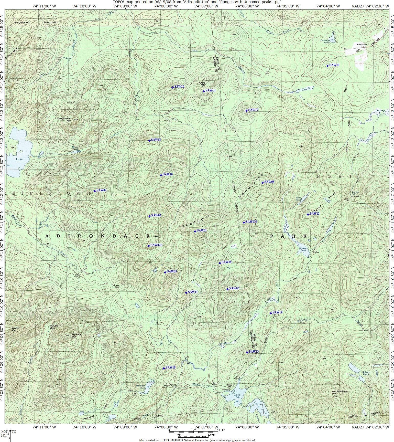
Table of the 20 Peaks in the Sawtooth
Range
Numbered #1 to #20.
4 do have names. #1 and #2 are called Raker and Cutter, I still used them even though these names no longer appear on metric maps. #12 is called Three Peaks Mt and #14 is called Alford Mt. In order to keep the traditional #'s 1-5, the two peaks that are higher than 3 & 5 were named #2S and #1E and there are no Sawtooth #6 & #7
For full size map (1540x1726, 996K) Click Here
| #Number/Name | Meters | Feet | 200/300 rule |
Location | Summit Cord. | Comments |
| #1 | 1170 | 3839 | 300 |
Center of the range. | 44°11'20"N 74°07'16"W |
Double summit. Highest contour line 1170m on SW summit. BM 1142m on smaller NE summit. |
| #2 | 1150 | 3773 | 300 |
West of #1 | 44°11'36"N 74°08'23"W |
3 summits. BM 1129m on middle summit and BM 1084m on S summit. Highest Contour line 1150m on N summit |
| #2S | 1140 | 3757 | 200 |
South of #2 | 44°11'04"N 74°08'24"W |
Highest contour line 1140m. 200 foot rule only, so technically it is not a mountain on it's own but part of #2. It was not giving any rank and is left out of my Mountain list and was put in my "Not Real Mountains" section. Given the designation #2S in order to keep the traditional #'s 1-5 |
| #3 | 1126 | 3694 | 300 |
SW of #1 | 44°10'18"N 74°06'28"W |
BM @ 1126m |
| #1E | 1080 | 3560 |
200 |
E of #1 |
44°11'29"N |
Highest contour line 1080m. 200 foot rule only, so technically it is not a mountain on it's own but part of #1. It was not giving any rank and is left out of my Mountain list and was put in my "Not Real Mountains" section. Given the designation #1E in order to keep the traditional #'s 1-5 |
| #5 | 1050 | 3445 | 300 |
S of #1 & #2 | 44°10'36"N 74°08'00"W |
Highest Contour Line@1050m. NW side just rises 300 feet, all other sides
more.
The 1955 USGS (standard maps used by ADK) has both peaks at the same height, The ADK choose the #4 and #5 designations because one peak is more massive than the other. The 1978 USGS (metrics) puts the less massive peak 9 meters higher. Kept it as #5 for tradition |
| #4 | 1041 | 3415 | 200 |
NW of #2 | 44°12'03"N 74°09'44"W |
BM@1041m. See above. |
| #8 | 1032 | 3386 | 200 |
NE of #1 | 44°12'12"N 74°05'36"W |
BM@1032m. 200 foot rule only, so technically it is not a mountain on it's own but part of #3. It was not giving any rank and is left out of my Mountain list and was put in my "Not Real Mountains" section. |
| #9 | 1030 | 3379 | 200 |
NW of #3 | 44°10'46"N 74°06'39"W |
Highest Contour Line @1030m. 200 foot rule only, so technically it is not a mountain on it's own but part of #3. It was not giving any rank and is left out of my Mountain list and was put in my "Not Real Mountains" section. |
| #10 | 1001 | 3284 | 200 |
N of #2 | 44°12'20"N 74°08'06"W |
BM@1001m 200 foot rule only, so technically it is not a mountain on it's own but part of #2. It was not giving any rank and is left out of my Mountain list and was put in my "Not Real Mountains" section. |
| #11 | 910 | 2986 | 200 |
S of #1, W of #3 | 44°10'14"N 74°07'29"W |
Highest Contour Line @910m. 200 foot rule only, so technically it is not a mountain on it's own but part of #1. It was not giving any rank and is left out of my Mountain list and was put in my "Not Real Mountains" section. |
| #12 | 896 | 2940 | 300 |
E of #1 | 44°11'38"N 74°04'29"W |
Named Three Peaks Mt. BM @896. |
| #13 | 830 | 2723 | 300 |
N of Duck Hole | 44°09'10"N 74°05'59"W |
Highest Contour Line @ 830M |
| #14 | 800 | 2625 | 300 |
N of #1 | 44°13'50"N 74°07'03"W |
Named Alford Mt. Highest Contour line @800m |
| #15 | 795 | 2595 | 200 |
N of #2 & #7 | 44°12'57"N 74°08'24"W |
BM@795m. 200 foot rule only, so technically it is not a mountain on it's own but part of #2. It was not giving any rank and is left out of my Mountain list and was put in my "Not Real Mountains" section. |
| #16 | 777 | 2549 | 300 |
W. of Alford Mt. | 44°13'54"N 74°07'49"W |
BM@777m. Rises 351 feet from col with Alford (#10) |
| #17 | 772 | 2533 | 300 |
SE of Alford Mt | 44°13'29"N 74°06'00"W |
BM@772m |
| #18 | 764 | 2507 | 200 |
NE of Mountain Pond | 44°08'53"N 74°08'02"W |
BM@764. 200 foot rule only, so technically it is not a mountain on it's own but part of #3. It was not giving any rank and is left out of my Mountain list and was put in my "Not Real Mountains" section. |
| #19 | 750 | 2461 | 200 |
N of #11 | 44°09'52"N 74°05'24"W |
Highest Contour Line @m. Double Summit at same contour line, used widest one. 200 foot rule only, so technically it is not a mountain on it's own but part of #11. It was not giving any rank and is left out of my Mountain list and was put in my "Not Real Mountains" section. |
| #20 | 680 | 2231 | 300 |
Near Averyville Trailhead | 44°14'17"N 74°04'00"W |
Highest Contour Line @680m. |
 |
 |