Adirondack Mountains 2000 ft to 2999 ft
(610 meters - 914 meters)
See Legend for Symbols
Pharaoh Mt. from Skifft Mt.
| Rank | Name,Height, Rating,Field of view,crowd factor,How to get there,comments |
| 164 | T Lake #3 2,995 |
| 165t | Height of Land Mt. 2,992 |
| 165t | West Canada Mt. (West Canada #1) 2,992 |
| 165t | Unnamed (E. of Northrup Lake) 2,992 |
| 168t | Grass Mt. 2,989 Was over 3000 feet on the 1955 maps, now it's under |
| 168t | Moose Mt.(W. of Newcomb Lake) 2,989 |
| 168t | Humphrey Mt. 2,989, **, +oks, pc, P+B, R The old garnet mine is more of target than the summit |
| 171 | Unnamed (Sw of Street) 2,986 |
| 172 | Kunjamuk Mt. 2,979 |
| 173t | Twin Lakes Mt. (T Lakes #4) 2,976 |
| 173t | T Lakes #5 2,976 |
| 173t | Wilmurt Mt. 2,976 |
| 176 | T Lakes #6 2,972 |
| 177 | Noisy Ridge 2,969 |
| 178 | Speculator 2,966 |
| 179 | Tirrell Mt. 2,963 Unnamed on 1955 maps |
| 180 | Black Mt. (Sentinels) 2,959 No *'s, none, DS, B, X |
| 181 | Wilson Ridge 2,956 |
| 182t | Unnamed (SE of Mt. Alton) 2,953 |
| 182t | West Canada #2 2,953 |
| 184t | Hayes Mt 2,940 |
| 184t | Mt. Hoevenberg 2,940 **** ~180, PC, Ts, PG, Same view as Mt. Jo & Phelps, with a better view of Gothics |
| 184t | Sand Pond Mt. 2,940 |
| 184t | Three Peaks (Sawtooth #12) 2,940 |
| 188 | Blue Hills(Mud Ponds) 2,936 |
| 189t | Big Burn Mt. 2,930 |
| 189t | Kitty #8 2,930 |
| 191t | Beaver Mt. 2,926 |
| 191t | Rock Pond Mt. 2,926 |
| 193 | Unnamed (S of Spoon Lake) 2,923 |
| 194 | Bluff Mt 2,920 |
| 195t | Buck Mt. (e. of Mt. Morris) 2,917 |
| 195t | Unnamed (E. of Big Range) 2,917 |
| 197t | Mt.Blue (Garnet Lake) 2,913 *** ,>200, DS, B + Bt, X Yes, amazingly a mountain with the word "Blue" in it's name that actually has good view. Steep Bushwhack, lots of rock faces to get around. Great view of Crane Mt. and vicinity. Easier to get to in winter when you can walk across Garnet Lake, summer you need a boat. |
| 197t | Peaked Mt.(Peaked mt. pond) 2,913 **, >200, PUC, T, PG13 |
| 197t | West Mt. (Raquette Lake) 2,913 |
| 197t | Unnamed (North River Mts) 2,913,,,, Sw of Rist Mt. |
| 197t | Hour Pond Mt. 2,913, No *'s, none, DS, B, R. |
| 197t | Seventh Lake Mt. 2,913,,,,, Colvin made winter ascent Feb 15 1877 and shot a pather |
| 203t | Sable Mt. 2,910s,,,,B |
| 203t | Kitty #9 2,910 |
| 205 | Jones Mt. (Kitty #10) 2,907 |
| 206 | Mt. Sabattis 2,904 |
| 207t | Unnamed (S of Noonmark) 2,900 |
| 207t | Haystack Mt. (E. of Norton) 2,900s |
| 209 | Onion Hill 2,894 |
| 210 | Moss Cliff 2,887 |
| 211 | Slide Mt.(NE peak mt pond) 2,881,** ,one, DS, B, R. No view from the summit Some views may be had from open ledges along top of south face |
| 212 | Mt. Jo 2,877 ****, ~180, JP, T, G Great Views little effort |
| 213t | Haystack Mt.(Mckenzie) 2,874 ****, ~180, PC, T, PG Excellent views of the distant High peaks. Bizarre design of the trail. Why it goes the way it does is beyond me. You can see almost all of the 46 High peaks from here. |
| 213t | St. Regis Mt. 2,874 *****(FTc),>200, PC, T, PG Great Lake Views & of the distant High Peaks and the vast NW frontier. Firetower is closed but who cares, no views are lost. |
| 213t | West Canada #3 2,874 |
| 213t | Unnamed (e. of Kibby Pond) 2,874 no *'s, none, DS, B, X. Note: the X approach is from Kibby Pond--it is undoubtedly much easier to approach from the Bartman Road. |
| 217t | Baldhead Mt. (Stony Creek) 2,870s, ***, d180, DS, B, R. |
| 217t | Norton Peak 2,870s **, +oks, Puc, B, R Has A Cave to Explore, Unfortunately lots of graffiti on the walls |
| 219t | Baldface Mt.(Debar pond) 2,867s, ***, >200, DS, B, R. Lots of open rock. Easy bushwhack. |
| 219t | Blue Ridge Mt. (3 ponds) 2,867 |
| 221 | Kitty #12 2,864 |
| 222t | Buckhorn Mt (NE of Macomber). 2,854 |
| 222t | Kitty #13 2,854 |
| 222t | Page Mt 2,854 |
| 222t | Stacy Mt. 2,854 |
| 222t | Sugarloaf Mt. (Three Ponds) 2,854 |
| 227t | Kate Mt. (West Summit) 2,841, ***, >200, DS, B, R. Extensive views south across the Saranac Intramontane Basin to the High Peaks. |
| 227t | Unnamed (w of Andrew) 2,841 |
| 229t | Baldwin Mt. 2,838 |
| 229t | Unnamed (SE of Big Range) 2,838 |
| 231t | Moose Mt.(Stony Creek) 2,831s, ***, 360t(Bigmt), DS, B, R. View south blocked by Baldhead. |
| 231t | West Canada #4 2,831 |
| 233 | Little Blue Mt. (Blue Mt Lake) 2,825 *,one, DS,B,X Short, Somewhat Steep Bushwhck, Some screened views from a small slide, none from the summit |
| 234 | T Lake #7 2,815 |
| 235t | Kitty #15 2,812 |
| 235t | Owl's Head (long Lake) 2,812 (FTc) ***, ~180, PC, T, PG. Fire tower slated to be restored but as of 7/02 it is falling apart and dangerous. Small summit veiwing area. Trail seems much longer than the stated 3.1 miles but still a releatively easy climb. |
| 237 | Kitty #16 2,808 |
| 238 | Moose Mt. (3 ponds) 2,805 |
| 239 | Round Top (NE of Wakely) 2,802 |
| 240 | Loon Lake #4 2,800s |
| 241t | Green Mt. (Minerva, SW Summit) 2,799 |
| 241t | Kettle Mt. (SW summit) 2,799 no *'s, none, DS, B, R |
| 241t | Unnamed(E Pilgrim Pond) 2,799 |
| 244t | Crotched Pond Mt. 2,795 |
| 244t | Horseshoe Mt.2,795 |
| 244t | Panther Mt.(Kitty #17) 2,795 |
| 244t | Unnamed (N. of Cedar Lake) 2,795 |
| 248 | Elbow Range (NE Summit) 2,792s |
| 249 | Camels Hump 2,789 ***** 360, DS, P, X, Great Views of Giant,Dix and Walker valley ranges. Lots of boulders to climb over. |
| 250 | Pilgrim Mt. (SE Pilgrim Pond) 2,785 Highest Mountain in Fulton County |
| 251 | Pigeon Mt. (E of county line lake) 2,780s |
| 252t | Big 13th Lake Mt. 2,779 ***, >200, DS, B, R. |
| 252t | Sugarloaf Mt.(E. of Wakley) 2,779 |
| 252t | Windfall Mt. 2,779 |
| 255 | Unnamed (W.of Wilmurt Lake) 2,776 Bethune Mt is the lower summit |
| 256t | Pitchoff (Hurricane) 2,772 *** one, DS, B, X, Vertical Cliff seen from Rt. 9N, Good veiws from an open area SE of the summit and the cliffs, not much from the summit. |
| 256t | Round Mt (Grassy River) 2,772 |
| 258t | Metcalf Range 2,769 |
| 258t | Pigeon Roost 2,769 |
| 260t | Grampus Lake Mt.2,766 |
| 260t | Unnamed (Higher summit bearpin peak) 2,766 Many Summits, Bearpin Peak only one with a name, highest peak unnamed |
| 262t | Kitty #19 2,762 |
| 262t | Pine Pond Mt. 2,762 Unnamed on Metric Maps |
| 262t | Spruce Mt. (n. of Wilmut Lake) 2,762 |
| 265 | Twin Mt. 2,759 |
| 266t | East Mt.(SE of dug) 2,756 |
| 266t | Tenant mt. 2,756 (FT?) Highest Mountain in Saratoga County |
| 266t | Unnamed (e. of Pilgrim mt) 2,756 |
| 269 | Black Mt.(Bakers Mills L) 2,746 |
| 270 | Ragged Lake Mt. 2,740s |
| 271 | Kate Mt (East Summit) 2,739 |
| 272t | Cross Mt 2,736 |
| 272t | Piseco Mt. 2,736 |
| 274 | Duncan Mt. 2,729s *, one, DS, B, X One screened view towards Silver Lake |
| 275 | Sawtooth #13 2,723 |
| 276t | FloodWood Mt. (Indian Lake) 2,720 |
| 276t | Mt. Tom (Plumadore Range) 2,720s |
| 276t | Wallace Mt. 2,720 |
| 279t | North Branch Mt. 2,717 |
| 279t | Panther Mt (Echo Cliff) 2,717 |
| 281 | Chimney Mt (W of Bullhead) 2,710 |
| 282t | Moose Mt. (SE of Allen) 2,707 |
| 282t | Unnamed (NW. of Burgess) 2,707 |
| 284t | Clear Pond Mt. 2,703 ***, +oks, PV, B, Short & Steep bushwhack, Some good views toward the high peaks in winter, Elk Lake probably doesn't allow access |
| 284t | Lookout Mt. (Loon Lake) 2,703s |
| 284t | Ragged Mt. 2,703,,,,Pv, Bizarre shaped Mt.on Rt. 2. Hard to image with it's awesome rock faces that it's not more then 3000ft high. |
| 287t | Buck Mt. (Hope Falls) 2,700 |
| 287t | Ellenburg Mt. 2,700s ***,~180, DS, B&P |
| 287t | W mt. 2,700s |
| 290t | Unnamed (E of Amos Lake) 2,697 |
| 290t | Unnamed (S. of Snyder Lake ) 2,697 Highest Mountain in Herkimer County, lots of summits everywhere. |
| 290t | Unnamed (S. of Buck Pond, wells) 2,697 |
| 293t | Unnamed (W. of Ampersand) 2,694 |
| 293t | Unnamed (W. of Seward) 2,694 |
| 295 | Goodnow Mt. 2,690 *** (FT) one, PC, T, G, There is one decent overlook before the summit, but despite what is written in the guide books there are no good ground level views on the summit only a few screened views, There are good views are from the tower. |
| 296 | Mt. Matumbla 2,688s (FT?) Highest Mountain in St. Lawrence County |
| 297 | Unnamed (E of Kempshall) 2,687 |
| 298 | Catlin Mt 2,684 |
| 299t | Hadley Mt. 2,680s *****(FT) ~180, JP, T, PG, On a really, really clear day you can see NY's 2 Highpoints Mt. Marcy & Branch Slide of the Catskills |
| 299t | Hail Mt. 2,680 - Highest Mountain East of the Northway |
| 299t | Ice Cave Mt. 2,680 |
| 299t | Unnamed (NW of Puffer Pond) 2,680 |
| 303t | Ross Mt. 2,677 |
| 303t | Tomany Mt 2,677 (FT?) |
| 303t | Unnamed (NE Vanderwhacker) 2,677 |
2,672 -- Half Mt. Marcy's Height -- 2,672 |
|
| 306t | Pollack Mt. 2,664 |
| 306t | Mt. Tom (Old Forge) 2,664 |
| 308t | Buck Mt.(e. of Kempshall) 2,661 |
| 308t | Little Beaver Mt. 2,661 |
| 308t | Smith Mt. 2,661 |
| 311t | Ruby Mt. 2,657 **, +oks, DS, B, X The view rating from the summit must be characterized as poor, but those from outlooks along the southeasterly side are quite extensive--nearly 180 degrees. |
| 311t | Thompson Mt. 2,657 |
| 311t | West Canada #7 2,657 |
| 314 | Blue Mt (NE Whiteface) 2,654 |
| 315 | Long Pine Mt. 2,651 |
| 316 | Spruce Mt. (Stony Creek) 2,650s |
| 317 | Mt. Whitney 2,648 |
| 318 | Potash Mt. (s. of Pilsbury) 2,641 |
| 319 | Black Mt. (Lake George) 2,640s *****(FTc) +oks, PC, T, PG Awesome Views of the whole Lake George basin and surrounding Mountains. Has a Windmill on top. Firetower fenced in and off limits to the public. |
| 320t | Mt. Orrey 2,638 |
| 320t | Sherman Mt 2,638 |
| 320t | T Lake #9 2,638 Lots of Summits all over the place, highest summit to the east of the range |
| 320t | Unnamed (NW of Ragged) 2,638 |
| 324t | Morehouse Mt. 2,634 |
| 324t | Unnamed (W of St. John Lake) 2,634 |
| 326 | Raymond Hills 2,631 |
| 327t | Bitch Mt. 2,628 |
| 327t | Green Mt. (Minerva, NE Summit) 2,628 |
| 329t | Alford Mt. (Sawtooth #14) 2,625 |
| 329t | Loon Lake #5 2,625s |
| 329t | Peaked Mt. (N. of Blue Mt. Lake) 2,625 |
| 329t | Unnamed (Macintyre Range) 2,625 ,,,,, Smallest Mountain in the Macintye range |
| 333t | Kitty #27 2,621 |
| 333t | Spurce Mt.(W of sand lake) 2,621 |
| 333t | Mt. Tom (SW of Bear Pond) 2,621 |
| 336t | Green Top 2,618 |
| 336t | Harrington Mt. 2,618 |
| 336t | Sawyer Mt. 2,618 *, one, PC, T, G, Easy mt. to climb, small viewing area that unfortunately doesn't overlook anything interesting |
| 339t | Ely Mt. 2,615 |
| 339t | Unnamed (N. of Honnedaga Lake) 2,615 Quadruple Summit on the North Shore |
| 341t | Alder Brook Mt. 2,612s |
| 341t | Blueberry Mt (E. of Kempshall) 2,612 *** +oks, DS,B,R Some good views of Long Lake and Lake Eaton, lots of cliffs to get around but fairly straight forward bushwack. |
| 343 | Indian Lake Mt (SW Small Indian Lake(Honnedaga) 2,605 |
| 344 | Unnamed (NE of Sucker Pond) 2,602 |
| 345t | Canachagala 2,598 |
| 345t | Unnamed (E of Little Moose Mt) 2,598 |
| 345t | Unnamed (E of St John Lake) 2,598 |
| 348 | Long Tom Mt.(NE of L. Marian) 2,595 |
| 349 | Lyon #5 2,593s |
| 350 | Unnamed (NE of Sargent Ponds) 2,592 |
| 351 | Slip mt. (Livingston lake) 2,589 |
| 352 | Silver Lake Mt. (Se Lake Marian) 2,585 |
| 353t | Scotts Cobble 2,582 |
| 353t | Unnamed (NE of Terror Lake) 2,582 |
| 355t | Big Marsh Mt 2,579 |
| 355t | Unnamed (SW of Barto Lake) 2,579 |
| 355t | Unnamed (W of Chimney Mt) 2,579 |
| 355t | Unnamed (N of Little Salmon Lake) 2,579 |
| 359t | Cherry Ridge 2,576s |
| 359t | Wolf Pond Mt. (S of Crane) 2,576s |
| 361 | Buck Meadow Mt. 2,572 |
| 362 | Davis Mt 2,569 |
| 363 | Ohmer Mt. 2,566 |
| 364t | T Lake #10 2,562 |
| 364t | Unnamed (SE of lake Mohegan) 2,562 |
| 366t | Clements Mt. 2,559 Seen straight ahead coming down the big hill from Cascade Lakes |
| 366t | Unnamed (E of Lake Pleasent) 2,559 |
| 366t | Unnamed (N of Sargent Ponds) 2,559 |
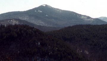
| 369t | Pharaoh Mt. 2,556s *****, d180, JP, T, PG, Imposing Looking mountain seen from the Northway across Scroon Lake. Great View of the High peaks, Central mountains, and Pharaoh Mt. Wilderness. Firetower long gone but who cares. So far the locals won over the DEC so you can drive down the road and park at Crane Pond. |
| 369t | Starbuck Mt. 2,556s |
| 371 | Unnamed (S. of Morehouse Mt) 2,552 - Smaller summit named Big Alderbed Mt. |
| 372t | Sawtooth #16 2,549 |
| 372t | State Brook Mt. 2,549 |
| 372t | Wheeler mt. 2,549 |
| 375 | Big Hopkins mt 2,543 |
| 376 | Mud Pond Mt. (Loon Lake) 2,541s |
| 377t | Black Bear Mt. (W of Bug Lake) 2,539 |
| 377t | Cedar Mt (Cedar & Hudson Rivers) 2,539 |
| 377t | Unnamed (W of Lake Eaton) 2,539 |
| 377t | Unnamed (W of Garnet Lake) 2,539 |
| 377t | Unnamed (SE of Zack Pond) 2,539 |
| 382 | Buck Mt. (Brandreth Lake) 2,536 |
| 383 | Sawtooth #17 2,533 |
| 384t | Estelle Mt. 2,529 |
| 384t | Long Pond Mt. (Santa Clara) 2,529 |
| 386 | Erebus mt 2,527s |
| 387t | Beech Ridge (Elk Lake) 2,526 |
| 387t | Unnamed (W of Big Sister Lake) 2,526 |
| 389t | Black Ash mt. 2,523 |
| 389t | Salmon Lake Mt. (FT?) 2,523 |
| 391t | Arab Mt. 2,520 ***(FT), none, PC,T,G |
| 391t | Lamphere Ridge 2,520 |
| 391t | Porter Hill 2,520 |
| 391t | Rice Mt 2,520s |
| 395t | Poplar Mt. 2,516 |
| 395t | Unnamed (NW of Sand Lake) 2,516 |
| 397t | Fawn Lake Mt. 2,513 |
| 397t | Jenkins Mt. 2,513, **, One, PUC, T, PG13. Good views along the trail. Note: the trail does not go to the actual summit where the views are poor, but stops at a lookout on the west end of the summit ridge. |
| 399t | Boot Bay Mt. 2,510 |
| 399t | Rogers Mt. 2,510 |
| 401t | Reservoir Mt 2,503 |
| 401t | Unnamed (E of Horn Lake) 2,503 |
| 403t | Azure Mt. 2,500 ****(FT) >200, PUC, T, G Way, Way out there.It takes longer to drive to this mt.than to climb it. Lots of vastness. Fire tower has been or is in process of being restored. |
| 403t | Bear Mt. (W. Dog Pond mt) 2,500 |
| 403t | Cascade Mt 2,500 |
| 403t | Joseph Mt (Fishingbrook) 2,500 |
| 403t | Johnson Mt. (E of Lyon) 2,500 |
| 403t | Little McKenzie 2,500 |
| 403t | Moose Pond Mt.(E. of Sutton Pond) 2,500 |
| 403t | Polaris Mt. 2,500 |
| 403t | Unnamed (E of Baby Lake) 2,500 |
| 403t | Unnamed (S of Lewey Lake) 2,500 Highest Contour line @ 762m (2500ft), Lower BM off to the side @767m (2516ft), may be in error |
| 403t | Unnamed (NE of Mitchell Ponds) 2,500 |
| 403t | Unnamed (W Silver Dollar Pond) 2,500 |
| 403t | Unnamed (S of Terror Lake) 2,500 |
| 416 | Pinnacle 2,496 (W of Chase Lake) |
| 417t | Lyon #7 2,493 |
| 417t | Unnamed (E of St. Regis Mt) 2,493 |
| 419 | Wolf Pond Mt (SW of Santanoni) 2,487 |
| 420t | Casey Mt 2,483 |
| 420t | Unnamed (SW of Shingle Shanty Pond) 2,483 |
| 422t | Iron Mt (Upper Saranac Lake) 2,480 |
| 422t | Hogback 2,480 |
| 422t | Mitchell Ponds Mt 2,480 |
| 422t | Panther Mt (W of Chase Lake) 2,480 |
| 422t | Unnamed (Bakers Mills) 2,480 |
| 422t | Unnamed (NW of Lake Kora) 2,480 |
| 428t | Oliver Hill 2,477 |
| 428t | Unnamed (N of Upper Sister Lake) 2,477 |
| 430 | Catamount Mtn (Loon Lake), 2,475s, ***, >200, DS, B, R |
| 431 | Fish Mt 2,474 |
| 432t | Christian Lake Mt 2,470 |
| 432t | Seymour (E of Scareface) 2,470 |
| 432t | West Creek Mt 2,470 |
| 432t | Unnamed (SW of Barnes Pond) 2,470 |
| 436t | Burnham Mt.2,467 |
| 436t | Higley Mt 2,467 |
| 436t | Willis Mt 2,467 |
| 436t | Unnamed (SE of Pigeon lake) 2,467 |
| 440t | Moxham Mt. 2,464 ,,,,Pv+RC, The 3 Awesome 600+ foot vertical rock faces you see south of the JCT of 28N & County Rt. 29 outside of Olmsteadville |
| 440t | Winfall Mt. 2,464 |
| 440t | Unnamed (NWof Sprague Pond) 2,464 |
| 443 | Summit Mt (Five Ponds, NE Peak) 2,463s |
| 444t | Castle Rock 2,461 ***, ~180, PC,T,PG Great view across Blue Mountain Lake. Trail is a little harder than what the guidebook suggest but still releativly easy. Much better than Blue Mountain down the block. |
| 444t | Durant Mt. 2,461 |
| 444t | Mt. Tom (W of Gull Lakes) 2,461 |
| 444t | Unnamed (N of Rob Pond) 2,461 |
| 444t | Unnamed (N of Sprague Pond) 2,461 |
| 444t | Unnamed (NE of Twitchell Lake) 2,461 |
| 444t | Unnamed (NE of Vanderwhacker) 2,461 |
| 451t | Mt. Baker 2,457, **, +oks, JP, T, G Many Lakes in View. Take the left fork at the beginning |
| 451t | Unnamed (Far E. of Brandreth Lake) 2,457 |
| 453t | Hewitt Pond Mt. 2,454 |
| 453t | Unnamed (W of New Pond) 2,454 |
| 453t | Unnamed (NE of Perrys Peak) 2,454 |
| 456t | Unnaned (S of Brandreth Lake) 2,451 |
| 456t | Unnamed (E of Indian & W Canada rivers) 2,451 |
| 456t | Unnamed (SW of St. Regis Mt) 2,451 |
| 459t | Albany Mt 2,447 |
| 459t | Georgia Mt 2,447 |
| 459t | Unnamed (E of Jones Lake) 2,447 |
| 462 | Gooseberry Mt.(W of Santanoni) 2,444 |
| 463t | Goldsmith Mt. 2,442s |
| 463t | Hukleberry Mt 2,442s |
| 463t | Little Mt. 2,442s |
| 463t | Loon Lake #6 2,442s |
| 467t | Balm of Gilead Mt. 2,441 |
| 467t | Black Bear Mt. 2,441 |
| 467t | Indian Head (Wells) 2,441 |
| 467t | Pine Mt (S of G-Lake) 2,441 |
| 467t | Unnamed (SE of Brandreth Lake) 2,441 |
| 467t | Unnamed (SW of Razorback Pond) 2,441 |
| 473t | East Mt (E of Ingraham Pond) 2,440s |
| 473t | Flat Top 2,440s |
| 473t | Owl Pate 2,440 No *'s, none, DS, B+RC, Nice looking Mt. with the dome you see coming back on rt.2 to the Northway. |
| 473t | West Mt (W of Ingraham Pond) 2,440s |
| 477 | Dog Pond Mt 2,438 |
| 478 | Cathead Mt. 2,431, ***(FTc), ~180, PC, T,G |
| 479t | Baxter Mt. 2,428, *****, >200, PC, Ts,G Best Views in the Adirondacks for such little Effort. Unfortunately some @%$!# has build a house on the slopes of Tripod, which takes away some of the Wilderness experience, Hope the trees grow back fast. Where is the APA when you really need them. |
| 479t | Furance Mt. 2,428 |
| 479t | G Lake Mt. 2,428 |
| 479t | Pine Mt (Page Mt.) 2,428 |
| 479t | Unnamed (S of Mohegan Lake) 2,428 |
| 484t | Center Pond Mt. 2,425 |
| 484t | Golden Stair Mt. 2,425 |
| 484t | Panther Mt. (Old Forge) 2,425 |
| 484t | Pine Ridge (S of Crane Mt.) 2,425 |
| 488t | Figure Eight Mt 2,420s |
| 488t | Unnmaed (NW of Eastman Lake) 2,420s |
| 488t | Unnamed (S of Plumadore Range) 2,420s |
| 491t | Humbug Mt 2,415s |
| 491t | Sugarloaf Mt (Western Summit) 2,415s |
| 493t | Bay Pond Hill 2,411 |
| 493t | Long Pond Ridge 2,411 |
| 495 | Wolf Mt (Wolf Mt) 2,406s |
| 496t | Unnamed (West of Shingle Shanty Pond) 2,405 |
| 496t | Unnamed (S of Willy's Lake) 2,405 |
| 498t | Bluff Point Hill 2,402 |
| 498t | Feullard Mt 2,402 |
| 498t | Seneca Mt. 2,402 |
| 498t | Unnamed (E of Brandreth Lake) 2,402 |
| 498t | Unnamed (NE of Perrys Peak) 2,402 |
| 498t | Unnamed (N of Queer Lake) 2,402 |
| 498t | Unnamed (NW of Tirrell Pond) 2,402 |
| 498t | Unnamed (S of Upper Pond) 2,402 |
| 498t | Unnamed (E of Woods Lake) 2,402 |
| 507t | Moose Mt (Eagle Lake) 2,400s |
| 507t | Twin Mountain 2,400s |
| 507t | Wolf Pond Mt. (Ragged Lake) 2,400s |
| 507t | Unnamed (N of Holmes Lake) 2,400s |
Not going any further with the rankings Below are the more notable ones |
|
| Slide Mt.(Bloomingdale) 2,398 | |
| Silver Lake mt. 2,374s ***** ~180, PC, T, G Excellent Views of silver lake & Taylor pond | |
| ## | Snow Mt. 2,362 **** , ~180(bigmt), PC, T, PG Smallest mountain in the great range.Excellent Views all around. |
| Sleeping Beauty 2,347 **** >200, PUC, T, PG From the wide-open summit Lk George (Bolton Landing area)and Tongue Mountain Range are to west, Buck Mtn to south and Green Mtns to east. High Peaks visible in the distant NW. Several good lookouts on the loop trail. (Thanks To AP for the Info) | |
| Fort Noble Mt. 2,342 no *'s, none, DS, P, R Fire tower long gone. Easy to follow path , but in the beginning you have to cross a deep stream by rock jumping, swimming or climbing hand over hand on an old cable. | |
| Topknot Mt. 2,336 | |
| Stillwater Mt. 2,267(ft) no *'s, none, DS, T, PG Firetower still there but trees on summit have grown higher than the tower. Trail is starting to disappear, It is about a 20 mintue hike, the hardest part is the last section where it goes almost straight up... and you have to climb the rocks.. (Thanks to guys at Rap-Shaw for the info/update) | |
| Cat Mt.(Cranberry Lake) 2,260 ****, ~180, PUC, T, PG The approach hike is long but easy. The climb up the mountain is not much harder than walking up a hill in one's local park, but the views that the summit offers some utterly breathtaking views. (Thanks to MF for the info). There was a Firetower on summit but it is gone. | |
| Mt. Fredrick 2,260, ***, ~180, Puc,T, PG | |
| Coney Mt 2,250 | |
| Treadway Mt 2,246s **** >200, PUC, T, PG-13 Great open ridge walk, Bad design of the trail, too many pointless ups and down makes this mountain a lot harder than it has to be. Map has this Mt. as 2240 feet on the summit there is a DEC sign saying it's 2246. Went with the DEC. | |
| Moose River Mt. 2,244(FT?) Firetower is (or was) not on the highest summit | |
| Sawtooth #20 2,231 Lowest Peak in the Sawtooth range | |
| Titusville Mt. 2,204s ***, >200, DS, B, X 450 foot cliff | |
| Panther Mt.(Saranac Lake) 2,199 ***,+oks, PC, T, G | |
| Brewster Mt. 2,193 | |
| Kane Mt. 2,180s (FT) **, none, PUC, T, G | |
| ## | Pokomoonshine 2,162,*****(FT), ~180, JP, T, PG 1000 foot vertical cliff seen from the Northway by exit 33. Firetower put into good shape by volunteers. Now you can get a trail brochure at the trailhead. The Most Awesome view of Lake Champlain for such little effort. On a clear day you can see both Bridges across lake Champlain. Spelling on metric maps has it at Pokamoonshine, but the campground has it with an "O" and everyone around here also pronounces it with an "O" |
| Dannemora Mt. 2,140 no *'s, one,DS, B, X Great View of the Prison! | |
| Bad Luck Mt. 2,136 | |
| Watch Hill 2,126 **, one, PC, T, G Good View of the Slide on Snowy. Hard to find the trailhead. | |
| ## | Owls Head (Cascade Lakes) 2,120, ***, +oks, JP, P, G 2nd easiest mountain to climb. Great Views. Path very worn down, easy to follow. |
| ## | Meenahga Mt. 2,067(ft?) |
| Moosehead Mt.(Childwod) (Ft?) 2,067 | |
| Bald Peak (Port Henry) 2,051 ***, one, DS, P+B, R Good views towards the High Peaks | |
| ## | Prospect Mt. 2,040s ***, ~180, JP, D, G |
To many peaks unnamed to even attempted to get them all
I'm pretty confident that I have all the mountains above 2500', 2400-2999 I'm less so
I need your help to make this list complete. Do you have information on a Mountain that I don't? Or is there any information you feel needs updating? I created an easy to use form that you can report a mountain. Click Here
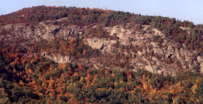
Pok-O-Moonshine Cliffs and Firetower
Web Designed By Qam1 ©2006